
District of Banská Bystrica topographic map
Interactive map
Click on the map to display elevation.
About this map
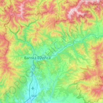
Name: District of Banská Bystrica topographic map, elevation, terrain.
Average elevation: 2,444 ft
Minimum elevation: 942 ft
Maximum elevation: 5,699 ft
Other topographic maps
Click on a map to view its topography, its elevation and its terrain.
Donovaly
Slovakia > Region of Banská Bystrica > District of Banská Bystrica > Donovaly
Donovaly, District of Banská Bystrica, Region of Banská Bystrica, Central Slovakia, 976 39, Slovakia
Average elevation: 3,366 ft