
Make a donation
Gear up for your next adventure:
As an Amazon Associate, this site earns from qualifying purchases at no extra cost to you.
Donovaly topographic map
Click on the map to display elevation.
Make a donation
Gear up for your next adventure:
As an Amazon Associate, this site earns from qualifying purchases at no extra cost to you.
Donovaly
Donovaly is a part of Low Tatras National Park, and it hosts one of the biggest and most popular ski resorts in Slovakia. Elevation is between 910 – 1,402 m, and there are more than 11 km of ski slopes, 17 lifts and elevators. In 2006, the Telemix lift by POMA, France – the 3rd of this kind in the world – was installed. It consists of 6 seated lift chairs, and 8 seated cabins, so the skiers can choose how they will go up to the top. Winter season starts from end of November and lasts until late March, beginning of April. It is also renowned for its dogsled racing championships.
Make a donation
Gear up for your next adventure:
As an Amazon Associate, this site earns from qualifying purchases at no extra cost to you.
About this map
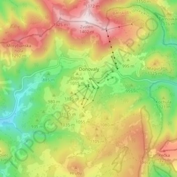
Name: Donovaly topographic map, elevation, terrain.
Average elevation: 3,366 ft
Minimum elevation: 2,310 ft
Maximum elevation: 4,593 ft
Make a donation
Gear up for your next adventure:
As an Amazon Associate, this site earns from qualifying purchases at no extra cost to you.