
Make a donation
Gear up for your next adventure:
As an Amazon Associate, this site earns from qualifying purchases at no extra cost to you.
Wels topographic map
Click on the map to display elevation.
Make a donation
Gear up for your next adventure:
As an Amazon Associate, this site earns from qualifying purchases at no extra cost to you.
Wels
Wels is in the Hausruckviertel at an elevation of 317 metres (1,040 ft). From north to south, it extends over 9.5 kilometres (5.9 mi), from west to east over 9.6 kilometres (6.0 mi). 3.4% of the area is covered with forest, 23.5% is used for agriculture.
Make a donation
Gear up for your next adventure:
As an Amazon Associate, this site earns from qualifying purchases at no extra cost to you.
About this map
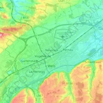
Name: Wels topographic map, elevation, terrain.
Location: Wels, Region Linz-Wels, Upper Austria, 4600, Austria (48.12582 13.96353 48.21131 14.09076)
Average elevation: 1,106 ft
Minimum elevation: 978 ft
Maximum elevation: 1,388 ft
Make a donation
Gear up for your next adventure:
As an Amazon Associate, this site earns from qualifying purchases at no extra cost to you.
Other topographic maps
Click on a map to view its topography, its elevation and its terrain.