
Make a donation
Gear up for your next adventure:
As an Amazon Associate, this site earns from qualifying purchases at no extra cost to you.
Jurm topographic map
Click on the map to display elevation.
Make a donation
Gear up for your next adventure:
As an Amazon Associate, this site earns from qualifying purchases at no extra cost to you.
About this map
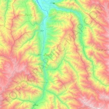
Name: Jurm topographic map, elevation, terrain.
Location: Jurm, Badakhshan Province, Afghanistan (36.49484 70.63790 37.00621 71.20708)
Average elevation: 9,803 ft
Minimum elevation: 4,544 ft
Maximum elevation: 17,287 ft
Make a donation
Gear up for your next adventure:
As an Amazon Associate, this site earns from qualifying purchases at no extra cost to you.
Other topographic maps
Click on a map to view its topography, its elevation and its terrain.
Koran va Monjan
Afghanistan > Badakhshan Province > Kuran wa Munjan
Owing to its altitude, Kuran wa Munjan features a subarctic climate (Dsc) bordering on a tundra climate (ET) under the Köppen climate classification. It has brief, pleasant summers and very cold, snowy winters. Winters are extremely long with below-freezing months from October until May. Summers are very…
Average elevation: 10,276 ft
Make a donation
Gear up for your next adventure:
As an Amazon Associate, this site earns from qualifying purchases at no extra cost to you.
Make a donation
Gear up for your next adventure:
As an Amazon Associate, this site earns from qualifying purchases at no extra cost to you.