
Thank you for supporting this site ❤️
Make a donation
Make a donation
Gear up for your next adventure:
As an Amazon Associate, this site earns from qualifying purchases at no extra cost to you.
Markyate topographic map
Click on the map to display elevation.
Thank you for supporting this site ❤️
Make a donation
Make a donation
Gear up for your next adventure:
As an Amazon Associate, this site earns from qualifying purchases at no extra cost to you.
About this map
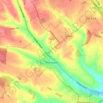
Name: Markyate topographic map, elevation, terrain.
Location: Markyate, Dacorum, Hertfordshire, England, United Kingdom (51.82541 -0.50342 51.85589 -0.43275)
Average elevation: 505 ft
Minimum elevation: 361 ft
Maximum elevation: 607 ft
Thank you for supporting this site ❤️
Make a donation
Make a donation
Gear up for your next adventure:
As an Amazon Associate, this site earns from qualifying purchases at no extra cost to you.