
Horsell topographic map
Interactive map
Click on the map to display elevation.
About this map
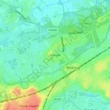
Name: Horsell topographic map, elevation, terrain.
Location: Horsell, Woking, Surrey, England, GU21 4QZ, United Kingdom (51.30469 -0.58687 51.34469 -0.54687)
Average elevation: 105 ft
Minimum elevation: 59 ft
Maximum elevation: 210 ft
Other topographic maps
Click on a map to view its topography, its elevation and its terrain.
West Byfleet
United Kingdom > England > Surrey > Woking
West Byfleet, Woking, Surrey, England, KT14 6BH, United Kingdom
Average elevation: 85 ft
Brookwood Country Park
United Kingdom > England > Surrey > Woking > Knaphill
Brookwood Country Park, Hermitage Woods, Knaphill, Woking, Surrey, England, United Kingdom
Average elevation: 154 ft
Old Woking
United Kingdom > England > Surrey > Woking
Old Woking, Woking, Surrey, England, GU22 9HD, United Kingdom
Average elevation: 102 ft
Brookwood
United Kingdom > England > Surrey > Woking
Brookwood, Woking, Surrey, England, GU24 0HG, United Kingdom
Average elevation: 157 ft
Sutton Green
United Kingdom > England > Surrey > Woking
Sutton Green, Woking, Surrey, England, GU4 7QD, United Kingdom
Average elevation: 105 ft
Mayford
United Kingdom > England > Surrey > Woking
Mayford, Woking, Surrey, England, GU22 0NL, United Kingdom
Average elevation: 115 ft
Knaphill
United Kingdom > England > Surrey > Woking
Knaphill, Woking, Surrey, England, GU21 2DG, United Kingdom
Average elevation: 141 ft
Horsell Common
United Kingdom > England > Surrey > Woking > Horsell > Durnford Farm
Horsell Common, Durnford Farm, Horsell, Woking, Surrey, South East England, England, United Kingdom
Average elevation: 95 ft
Byfleet
United Kingdom > England > Surrey > Woking
Byfleet, Woking, Surrey, England, KT14 7PN, United Kingdom
Average elevation: 89 ft