
Taraju topographic map
Click on the map to display elevation.
About this map
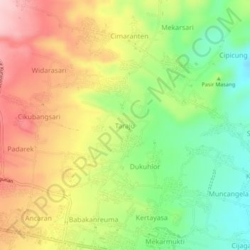
Name: Taraju topographic map, elevation, terrain.
Location: Taraju, Kuningan, West Java, Java, 45573, Indonesia (-6.97445 108.51401 -6.93445 108.55401)
Average elevation: 1,168 ft
Minimum elevation: 804 ft
Maximum elevation: 1,565 ft
Other topographic maps
Click on a map to view its topography, its elevation and its terrain.
Gunung Ciremai National Park
Indonesia > West Java > Kuningan > Padabeunghar
Average elevation: 2,881 ft