Geolocate

Castagnea topographic map

Click on the map to display elevation.

About this map

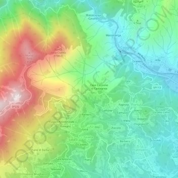
Name: Castagnea topographic map, elevation, terrain.

Location: Castagnea, Portula, Biella, Piemonte, 13833, Italia (45.65878 8.14383 45.69878 8.18383)

Average elevation: 2,503 ft

Minimum elevation: 1,450 ft

Maximum elevation: 4,541 ft

Gear up for your next adventure:

🧭GPS Watch Accessories - Bands and chargers for GPS watches
🎒Hydration Pack - Hands‑free water reservoir for long hikes
📻Weather Alert Radios - Stay informed of storm risks while off-the-grid
GPS Sports Watch - GPS watch for running, hiking and training
❄️Traction Cleats - Prevent slips on icy trails during winter hikes

As an Amazon Associate, this site earns from qualifying purchases at no extra cost to you.