
Make a donation
Gear up for your next adventure:
As an Amazon Associate, this site earns from qualifying purchases at no extra cost to you.
Moorslede topographic map
Click on the map to display elevation.
Make a donation
Gear up for your next adventure:
As an Amazon Associate, this site earns from qualifying purchases at no extra cost to you.
Moorslede
Moorslede ligt in Zandlemig Vlaanderen. De kerkdrempel ligt op ruim 45 meter hoogte. Het hoogste punt is 55 meter, in de beekdalen is de hoogte 20 tot 25 meter. In het zuiden stroomt de Heulebeek, in het oosten de Papelandbeek.
Make a donation
Gear up for your next adventure:
As an Amazon Associate, this site earns from qualifying purchases at no extra cost to you.
About this map
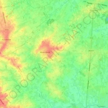
Name: Moorslede topographic map, elevation, terrain.
Location: Moorslede, Roeselare, West-Vlaanderen, Vlaanderen, 8890, België (50.85233 3.02733 50.92796 3.11765)
Average elevation: 98 ft
Minimum elevation: 23 ft
Maximum elevation: 190 ft
Make a donation
Gear up for your next adventure:
As an Amazon Associate, this site earns from qualifying purchases at no extra cost to you.
Other topographic maps
Click on a map to view its topography, its elevation and its terrain.
Make a donation
Gear up for your next adventure:
As an Amazon Associate, this site earns from qualifying purchases at no extra cost to you.