
Make a donation
Gear up for your next adventure:
As an Amazon Associate, this site earns from qualifying purchases at no extra cost to you.
Gavere topographic map
Click on the map to display elevation.
Make a donation
Gear up for your next adventure:
As an Amazon Associate, this site earns from qualifying purchases at no extra cost to you.
Gavere
Gavere ligt aan de Schelde en wel op de hogere oever, waar de hoogte oploopt tot 45 meter. Ten zuiden van de dorpskom ligt een sluis in de Schelde.
Make a donation
Gear up for your next adventure:
As an Amazon Associate, this site earns from qualifying purchases at no extra cost to you.
About this map
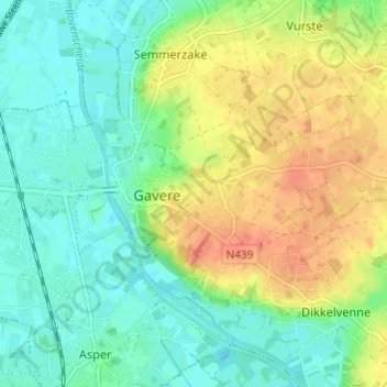
Name: Gavere topographic map, elevation, terrain.
Location: Gavere, Gent, Oost-Vlaanderen, Vlaanderen, 9890, België (50.91801 3.64872 50.94059 3.70930)
Average elevation: 59 ft
Minimum elevation: 10 ft
Maximum elevation: 151 ft
Make a donation
Gear up for your next adventure:
As an Amazon Associate, this site earns from qualifying purchases at no extra cost to you.
Other topographic maps
Click on a map to view its topography, its elevation and its terrain.
Gent
België > Oost-Vlaanderen > Gent > Gent
Een belangrijke waterloop voor Gent was de Lieve. De Lieve werd gegraven tussen 1251 en 1269 en vormde de eerste kunstmatige waterverbinding tussen Gent en de Noordzee. Over 45 km liep ze van Damme, waar ze in het Zwin uitmondde, naar Gent, waar ze in de Leie stroomde ter hoogte van het Gravensteen.
Average elevation: 39 ft
Make a donation
Gear up for your next adventure:
As an Amazon Associate, this site earns from qualifying purchases at no extra cost to you.