Geolocate

Cinque Confini topographic map

Click on the map to display elevation.

About this map

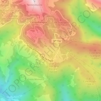
Name: Cinque Confini topographic map, elevation, terrain.

Location: Cinque Confini, Pian de' Valli, Rieti, Lazio, Italia (42.43608 12.98125 42.45608 13.00125)

Average elevation: 4,990 ft

Minimum elevation: 3,796 ft

Maximum elevation: 6,109 ft

Gear up for your next adventure:

📖Nature Tracking Books - Learn to track wildlife and terrain
🦺Reflective Outdoor Gear - Safety gear for low‑light conditions
🛰️Satellite Messengers - Emergency SOS and two-way messaging for off-grid adventures
🗺️NatGeo Topo Maps - High-quality waterproof printed topographic maps of US Parks
🥤Water Filter Bottle - All‑in‑one filter bottle for safe hydration

As an Amazon Associate, this site earns from qualifying purchases at no extra cost to you.