
Tonawanda topographic map
Click on the map to display elevation.
About this map
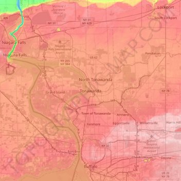
Name: Tonawanda topographic map, elevation, terrain.
Average elevation: 600 ft
Minimum elevation: 243 ft
Maximum elevation: 741 ft
Erie County trails, hiking, mountain biking, running and outdoor activities
Other topographic maps
Click on a map to view its topography, its elevation and its terrain.
Erie Canal
United States > New York > Erie County > City of Tonawanda
The construction of the Erie Canal was a landmark civil engineering achievement in the early history of the United States. When built, the 363-mile (584 km) canal was the second-longest in the world (after the Grand Canal in China). Initially 40 feet (12 m) wide and 4 feet (1.2 m) deep, the canal was expanded…
Average elevation: 581 ft
Village of Blasdell
United States > New York > Erie County > Town of Hamburg
Average elevation: 623 ft
Village of Sloan
United States > New York > Erie County > Town of Cheektowaga
Average elevation: 623 ft
Eighteen Mile Creek (Erie County)
United States > New York > Erie County > Highland-on-the-Lake
Average elevation: 636 ft
Red Jacket River Front Park
United States > New York > Erie County > Buffalo
Average elevation: 591 ft
Lakeview Road Town Recreation Area
United States > New York > Erie County > Town of Hamburg
Average elevation: 758 ft
Onondaga Escarpment
United States > New York > Erie County > Harris Hill > Town of Clarence > Eastern Hills
Average elevation: 673 ft
Village of Lancaster
United States > New York > Erie County > Village of Lancaster
Average elevation: 686 ft