
Make a donation
Gear up for your next adventure:
As an Amazon Associate, this site earns from qualifying purchases at no extra cost to you.
Acton topographic map
Click on the map to display elevation.
Make a donation
Gear up for your next adventure:
As an Amazon Associate, this site earns from qualifying purchases at no extra cost to you.
Acton
According to the United States Census Bureau, the town has a total area of 41.11 square miles (106.47 km2), of which 37.72 square miles (97.69 km2) is land and 3.39 square miles (8.78 km2) is water. Acton is drained by the Little Ossipee River, the Mousam River and the Salmon Falls River. The highest elevation in town is Hussey Hill, 1,051 feet (320.3 m) above sea level. Hussey Hill is also Maine's southernmost 1,000 foot (305 meter) mountain and only elevation above 1,000 feet in town.
Make a donation
Gear up for your next adventure:
As an Amazon Associate, this site earns from qualifying purchases at no extra cost to you.
About this map
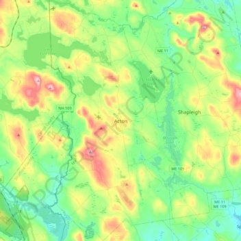
Name: Acton topographic map, elevation, terrain.
Location: Acton, York County, Maine, 04001, United States (43.45558 -70.97516 43.61441 -70.85774)
Average elevation: 607 ft
Minimum elevation: 354 ft
Maximum elevation: 1,086 ft
York County trails, hiking, mountain biking, running and outdoor activities
Make a donation
Gear up for your next adventure:
As an Amazon Associate, this site earns from qualifying purchases at no extra cost to you.
Other topographic maps
Click on a map to view its topography, its elevation and its terrain.
Make a donation
Gear up for your next adventure:
As an Amazon Associate, this site earns from qualifying purchases at no extra cost to you.
Make a donation
Gear up for your next adventure:
As an Amazon Associate, this site earns from qualifying purchases at no extra cost to you.