Geolocate

Augusta topographic map

Click on the map to display elevation.

About this map

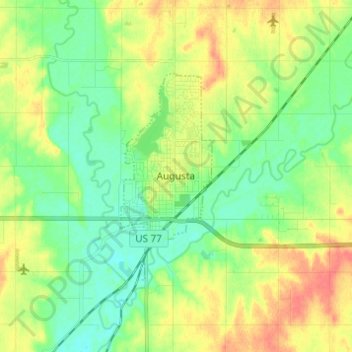
Name: Augusta topographic map, elevation, terrain.

Location: Augusta, Butler County, Kansas, 67010, United States (37.66264 -97.08037 37.71963 -96.95804)

Average elevation: 1,270 ft

Minimum elevation: 1,207 ft

Maximum elevation: 1,358 ft

Butler County trails, hiking, mountain biking, running and outdoor activities

Other topographic maps

Click on a map to view its topography, its elevation and its terrain.

Prospect

United States > Kansas > Butler County

Average elevation: 1,368 ft

Gear up for your next adventure:

⛑️Personal Locator Beacon - Safety beacon for emergencies
Backpacking Tent - Lightweight and durable tent for multi‑day hikes
🛏️Cold Weather Sleeping Bag - Warm sleeping bag for cold conditions
🪶LED Camping Lantern - Bright lantern for camp lighting
🎒Outdoor Daypacks - Lightweight backpacks designed for carrying maps and essential gear

As an Amazon Associate, this site earns from qualifying purchases at no extra cost to you.