Geolocate

Tay topographic map

Click on the map to display elevation.

About this map

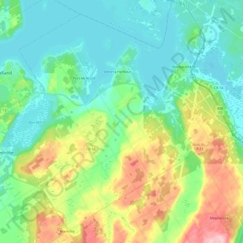
Name: Tay topographic map, elevation, terrain.

Location: Tay, Simcoe County, Central Ontario, Ontario, Canada (44.63291 -79.88118 44.79988 -79.66533)

Average elevation: 728 ft

Minimum elevation: 564 ft

Maximum elevation: 1,135 ft

Other topographic maps

Click on a map to view its topography, its elevation and its terrain.

Christian Island

Canada > Ontario > Simcoe County

Christian Island is a large island in Georgian Bay close to the communities of Penetanguishene and Midland, Ontario. The island, with its neighbours Hope Island and Beckwith Island, is a 5,428.1 hectares (13,413.1 acres) Ojibwa reserve, known as Christian Island Indian Reserve No. 30. Together with the 7.5…

Average elevation: 607 ft

New Lowell

Canada > Ontario > Simcoe County > Clearview

Average elevation: 689 ft

Colgan

Canada > Ontario > Simcoe County > Adjala–Tosorontio

Average elevation: 856 ft

Angus

Canada > Ontario > Simcoe County > Essa

Average elevation: 653 ft

Alliston

Canada > Ontario > Simcoe County

Average elevation: 764 ft

Wyevale

Canada > Ontario > Simcoe County > Tiny

Average elevation: 741 ft

Beeton

Canada > Ontario > Simcoe County

Average elevation: 794 ft

Udney

Canada > Ontario > Simcoe County > Ramara Township

Average elevation: 764 ft

Creemore

Canada > Ontario > Simcoe County > Clearview

Average elevation: 1,004 ft

Gear up for your next adventure:

Camping Coffee Makers - Enjoy premium coffee at the summit or campsite
🔪Outdoor Multitools - Essential survival tools for gear repair and field use
🏕️Tent Footprint - Protect your tent base from wear
🧭Orienteering Set - Complete compass and map reading kit
🥾Hiking Shoes - Durable and comfortable shoes for trail hiking

As an Amazon Associate, this site earns from qualifying purchases at no extra cost to you.