
Make a donation
Gear up for your next adventure:
As an Amazon Associate, this site earns from qualifying purchases at no extra cost to you.
Roxbury topographic map
Click on the map to display elevation.
Make a donation
Gear up for your next adventure:
As an Amazon Associate, this site earns from qualifying purchases at no extra cost to you.
Roxbury
More than twenty points within the town have an elevation of more than 2,000 feet (610 m); elevations in the town range from a low of 880 feet (270 m) (along the Third Branch of the White River) to a high of 3,086 feet (941 m) (at the peak of Rice Mountain). Rice Mountain lies in the Northfield range of the Green Mountains along the western boundary of the town.
Make a donation
Gear up for your next adventure:
As an Amazon Associate, this site earns from qualifying purchases at no extra cost to you.
About this map
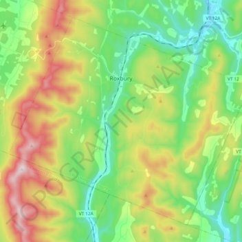
Name: Roxbury topographic map, elevation, terrain.
Location: Roxbury, Washington County, Vermont, 05669, United States (44.01281 -72.81894 44.12670 -72.63448)
Average elevation: 1,621 ft
Minimum elevation: 741 ft
Maximum elevation: 3,179 ft
Washington County trails, hiking, mountain biking, running and outdoor activities
Make a donation
Gear up for your next adventure:
As an Amazon Associate, this site earns from qualifying purchases at no extra cost to you.
Other topographic maps
Click on a map to view its topography, its elevation and its terrain.
Northfield Center
United States > Vermont > Washington County > Northfield
Average elevation: 1,119 ft
Make a donation
Gear up for your next adventure:
As an Amazon Associate, this site earns from qualifying purchases at no extra cost to you.
Northfield Center
United States > Vermont > Washington County > Northfield
Average elevation: 1,119 ft
South Cabot
United States > Vermont > Washington County > Cabot > South Cabot
Average elevation: 1,575 ft
Make a donation
Gear up for your next adventure:
As an Amazon Associate, this site earns from qualifying purchases at no extra cost to you.