
Shashikhal topographic map
Interactive map
Click on the map to display elevation.
About this map
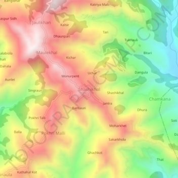
Name: Shashikhal topographic map, elevation, terrain.
Location: Shashikhal, Molekhal, Almora, Uttarakhand, 263676, India (29.63897 79.14474 29.67897 79.18474)
Average elevation: 3,914 ft
Minimum elevation: 2,562 ft
Maximum elevation: 5,161 ft
Other topographic maps
Click on a map to view its topography, its elevation and its terrain.
Jhimar
India > Uttarakhand > Molekhal
Jhimar, Molekhal, Almora District, Uttarakhand, India
Average elevation: 5,456 ft
Marchula
India > Uttarakhand > Molekhal
Marchula, Molekhal, Almora, Uttarakhand, India
Average elevation: 2,408 ft