Geolocate

Poplar Bluff topographic map

Click on the map to display elevation.

About this map

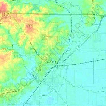
Name: Poplar Bluff topographic map, elevation, terrain.

Location: Poplar Bluff, Butler County, Missouri, 63901, United States (36.72138 -90.45631 36.80633 -90.36411)

Average elevation: 367 ft

Minimum elevation: 312 ft

Maximum elevation: 518 ft

Butler County trails, hiking, mountain biking, running and outdoor activities

Other topographic maps

Click on a map to view its topography, its elevation and its terrain.

Broseley

United States > Missouri > Butler County

Average elevation: 318 ft

Gear up for your next adventure:

🪓Survival Multi‑Tool - Versatile tool for camp and trail tasks
🔊Portable Camp Speaker - Music and alerts at camp
🔥Fast-Boil Camping Stoves - Efficient cooking systems for quick trail meals
🔋Solar Power Banks - Keep your GPS and phone charged in remote wilderness areas
🪄Magnetic Compass - Accurate compass for navigation

As an Amazon Associate, this site earns from qualifying purchases at no extra cost to you.