Geolocate

Rocky Butte topographic map

Click on the map to display elevation.

Rocky Butte

Rocky Butte lies in the northeast part of Portland within the city limits, in Multnomah County, part of the U. S. state of Oregon. It is one of the few smaller volcanic cones within or near Portland, along with Mount Tabor, Kelly Butte, and Powell Butte. According to the U.S. National Geodetic Survey, Rocky Butte has an elevation of 613 feet (187 m). It is surrounded on almost all sides by the Portland Delta.

Wikipedia (CC-BY-SA 3.0)

About this map

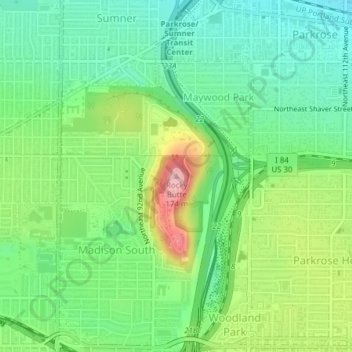
Name: Rocky Butte topographic map, elevation, terrain.

Location: Rocky Butte, Portland, Multnomah County, Oregon, 97220, United States (45.54653 -122.56598 45.54663 -122.56588)

Average elevation: 220 ft

Minimum elevation: 26 ft

Maximum elevation: 587 ft

Multnomah County trails, hiking, mountain biking, running and outdoor activities

Other topographic maps

Click on a map to view its topography, its elevation and its terrain.

Parkrose

United States > Oregon > Multnomah County > Portland

Average elevation: 85 ft

Dawson Park

United States > Oregon > Multnomah County > Portland

Average elevation: 148 ft

Hoyt Arboretum

United States > Oregon > Multnomah County > Portland

Hoyt Arboretum is sited on steep slopes, straddling the SW Fairview Boulevard ridge above the Oregon Zoo and the Portland Japanese Garden. The elevation of the arboretum ranges from 650 feet to 900 feet, and there are several ravines within the arboretum. The hilly terrain of the arboretum was once in private…

Average elevation: 686 ft

Marshall Park

United States > Oregon > Multnomah County > Portland

Average elevation: 417 ft

Hillsdale

United States > Oregon > Multnomah County > Portland

Average elevation: 479 ft

Mount Tabor

United States > Oregon > Multnomah County > Portland

Average elevation: 269 ft

King

United States > Oregon > Multnomah County > Portland

Average elevation: 197 ft

Empty

United States > Oregon > Multnomah County > Portland

Average elevation: 715 ft

Mill Park

United States > Oregon > Multnomah County > Portland

Average elevation: 299 ft

Glenwood Park

United States > Oregon > Multnomah County > Portland

Average elevation: 240 ft

Mill Park

United States > Oregon > Multnomah County > Portland

Average elevation: 299 ft

Mount Tabor

United States > Oregon > Multnomah County > Portland

Average elevation: 269 ft

Gear up for your next adventure:

🪶Compact Camp Shovel - Folding shovel for campsite tasks
📌Outdoor GPS Map App - Apps and devices for digital topographic navigation
🕶️Glacier Sunglasses - Side shields to protect eyes from high-altitude snow glare
🩹Survival Bandages - High‑quality bandages for emergencies
🌎3D Topographic Globes - Raised relief globes for a tactile understanding of geography

As an Amazon Associate, this site earns from qualifying purchases at no extra cost to you.