Geolocate

Malbang topographic map

Click on the map to display elevation.

About this map

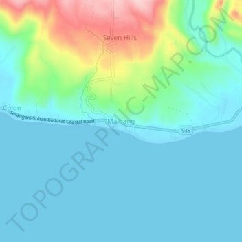
Name: Malbang topographic map, elevation, terrain.

Location: Malbang, Sarangani, Soccsksargen, Philippines (5.83482 125.00988 5.87482 125.04988)

Average elevation: 151 ft

Minimum elevation: 0 ft

Maximum elevation: 712 ft

Other topographic maps

Click on a map to view its topography, its elevation and its terrain.

Mainit River

Philippines > Sarangani

Average elevation: 915 ft

Sarangani Bay

Philippines > Sarangani

Average elevation: 338 ft

Malungon

Philippines > Sarangani

Average elevation: 1,522 ft

Glan River

Philippines > Sarangani

Average elevation: 1,260 ft

Maasim

Philippines > Sarangani

Average elevation: 676 ft

Buayan River

Philippines > Sarangani > Malungon

Average elevation: 489 ft

Gumasa Beach

Philippines > Sarangani > Glan

Average elevation: 197 ft

Malungon

Philippines > Sarangani

Average elevation: 1,509 ft

Malungon

Philippines > Sarangani

Average elevation: 1,522 ft

Gear up for your next adventure:

🛠️Outdoor Gear Repair Kit - Essential tools to fix gear on the trail
👖Convertible Hiking Pants - Versatile zip-off pants for changing altitudes and temperatures
📱Heavy-Duty Phone Cases - Drop-proof and waterproof protection for outdoor navigation
🧥Men's Rain Shells - Premium waterproof and breathable jackets for mountain weather
🥾Women's Hiking Boots - Top-rated trail boots with ankle support and superior grip

As an Amazon Associate, this site earns from qualifying purchases at no extra cost to you.