Geolocate

Geronimo topographic map

Click on the map to display elevation.

About this map

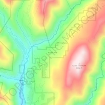
Name: Geronimo topographic map, elevation, terrain.

Location: Geronimo, San Miguel County, New Mexico, United States (35.80253 -105.66474 35.84253 -105.62474)

Average elevation: 8,911 ft

Minimum elevation: 8,107 ft

Maximum elevation: 9,852 ft

Other topographic maps

Click on a map to view its topography, its elevation and its terrain.

Las Vegas

United States > New Mexico > San Miguel County

Average elevation: 6,542 ft

Pecos

United States > New Mexico > San Miguel County

Average elevation: 6,991 ft

Las Vegas

United States > New Mexico > San Miguel County

Average elevation: 6,542 ft

Gear up for your next adventure:

🥾Men's Hiking Boots - Durable, waterproof footwear for rugged terrain and steep inclines
🛌Ultralight Sleeping Bags - Compact down bags for cold nights in the wilderness
📡Handheld GPS Device - Reliable handheld GPS for outdoor navigation
🩳Quick‑Dry Hiking Shorts - Comfortable and quick‑dry shorts for summer hiking
🦶Carbon Trekking Poles - Reduce knee impact on steep descents with ultra-light poles

As an Amazon Associate, this site earns from qualifying purchases at no extra cost to you.