
Make a donation
Gear up for your next adventure:
As an Amazon Associate, this site earns from qualifying purchases at no extra cost to you.
Cañaveral topographic map
Click on the map to display elevation.
Make a donation
Gear up for your next adventure:
As an Amazon Associate, this site earns from qualifying purchases at no extra cost to you.
Cañaveral
Cañaveral es la capital del distrito de Casitas, uno de los tres distritos de la provincia de Contralmirante Villar en el departamento de Tumbes, en el extremo noroeste del Perú. Cañaveral se encuentra a una altitud de 129 m s. n. m. Según el censo de 1999, tenía una población de 494 personas.
Make a donation
Gear up for your next adventure:
As an Amazon Associate, this site earns from qualifying purchases at no extra cost to you.
About this map
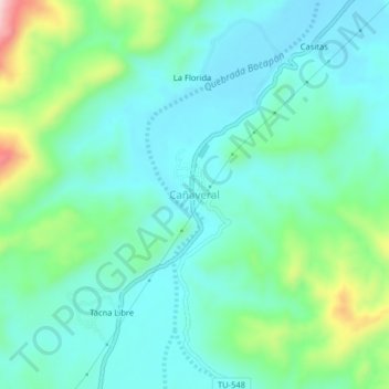
Name: Cañaveral topographic map, elevation, terrain.
Location: Cañaveral, Casitas, Contralmirante Villar, Tumbes, Perú (-3.96217 -80.67116 -3.92217 -80.63116)
Average elevation: 568 ft
Minimum elevation: 361 ft
Maximum elevation: 1,253 ft
Make a donation
Gear up for your next adventure:
As an Amazon Associate, this site earns from qualifying purchases at no extra cost to you.