
Hengke topographic map
Interactive map
Click on the map to display elevation.
About this map
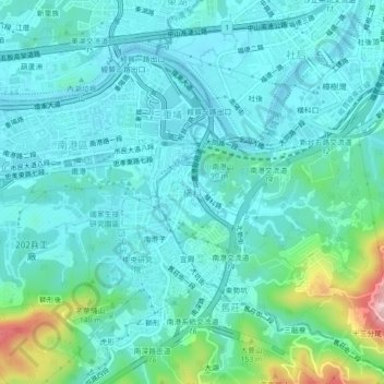
Name: Hengke topographic map, elevation, terrain.
Location: Hengke, New Taipei, 221004, Taiwan (25.02957 121.60036 25.06957 121.64036)
Average elevation: 144 ft
Minimum elevation: -10 ft
Maximum elevation: 801 ft
Other topographic maps
Click on a map to view its topography, its elevation and its terrain.
Special-use Zone of National Taipei University
Special-use Zone of National Taipei University, New Taipei, 23854, Taiwan
Average elevation: 164 ft
Xinchun Village
Xinchun Village, Tamsui District, New Taipei, Taiwan
Average elevation: 115 ft
Teapot Mountain
Teapot Mountain, New Taipei, 22448, Taiwan
Average elevation: 1,207 ft