
Ruifang District topographic map
Interactive map
Click on the map to display elevation.
About this map
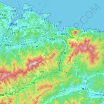
Name: Ruifang District topographic map, elevation, terrain.
Location: Ruifang District, New Taipei, Taiwan (25.04201 121.74985 25.13630 121.92480)
Average elevation: 571 ft
Minimum elevation: -13 ft
Maximum elevation: 2,402 ft
Other topographic maps
Click on a map to view its topography, its elevation and its terrain.
Special-use Zone of National Taipei University
Special-use Zone of National Taipei University, New Taipei, 23854, Taiwan
Average elevation: 164 ft
Xinchun Village
Xinchun Village, Tamsui District, New Taipei, Taiwan
Average elevation: 115 ft
Teapot Mountain
Teapot Mountain, New Taipei, 22448, Taiwan
Average elevation: 1,207 ft