
Thank you for supporting this site ❤️
Make a donation
Make a donation
Gear up for your next adventure:
As an Amazon Associate, this site earns from qualifying purchases at no extra cost to you.
Dhaula Kuan topographic map
Click on the map to display elevation.
Thank you for supporting this site ❤️
Make a donation
Make a donation
Gear up for your next adventure:
As an Amazon Associate, this site earns from qualifying purchases at no extra cost to you.
About this map
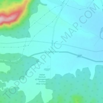
Name: Dhaula Kuan topographic map, elevation, terrain.
Location: Dhaula Kuan, Paonta Sahib, Sirmaur, Himachal Pradesh, India (30.48225 77.45377 30.52225 77.49377)
Average elevation: 1,542 ft
Minimum elevation: 1,401 ft
Maximum elevation: 2,362 ft
Thank you for supporting this site ❤️
Make a donation
Make a donation
Gear up for your next adventure:
As an Amazon Associate, this site earns from qualifying purchases at no extra cost to you.