
Make a donation
Gear up for your next adventure:
As an Amazon Associate, this site earns from qualifying purchases at no extra cost to you.
Greenwood topographic map
Click on the map to display elevation.
Make a donation
Gear up for your next adventure:
As an Amazon Associate, this site earns from qualifying purchases at no extra cost to you.
Greenwood
Greenwood's mean elevation is 813 feet (248 m) above sea level. The city's topography is flat to gently rolling.
Make a donation
Gear up for your next adventure:
As an Amazon Associate, this site earns from qualifying purchases at no extra cost to you.
About this map
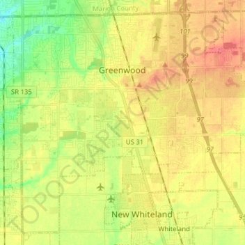
Name: Greenwood topographic map, elevation, terrain.
Location: Greenwood, Johnson County, Indiana, United States (39.54837 -86.16704 39.63693 -86.04000)
Average elevation: 804 ft
Minimum elevation: 709 ft
Maximum elevation: 886 ft
Johnson County trails, hiking, mountain biking, running and outdoor activities
Make a donation
Gear up for your next adventure:
As an Amazon Associate, this site earns from qualifying purchases at no extra cost to you.
Other topographic maps
Click on a map to view its topography, its elevation and its terrain.
Make a donation
Gear up for your next adventure:
As an Amazon Associate, this site earns from qualifying purchases at no extra cost to you.