
Make a donation
Gear up for your next adventure:
As an Amazon Associate, this site earns from qualifying purchases at no extra cost to you.
Socotra topographic map
Click on the map to display elevation.
Make a donation
Gear up for your next adventure:
As an Amazon Associate, this site earns from qualifying purchases at no extra cost to you.
Socotra
The main island has three geographical terrains: the narrow coastal plains, a limestone plateau with karst topography and the Hajhir Mountains. The mountains rise to 1,503 metres (4,931 ft). The island is about 125 kilometres (78 mi) long and 45 kilometres (28 mi) north to south.
Make a donation
Gear up for your next adventure:
As an Amazon Associate, this site earns from qualifying purchases at no extra cost to you.
About this map
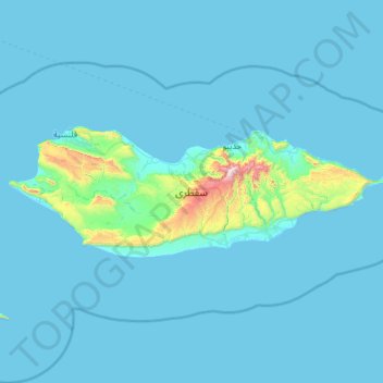
Name: Socotra topographic map, elevation, terrain.
Location: Socotra, Socotra Governorate, Yemen (12.30135 53.30537 12.71368 54.53431)
Average elevation: 210 ft
Minimum elevation: -3 ft
Maximum elevation: 4,921 ft
Make a donation
Gear up for your next adventure:
As an Amazon Associate, this site earns from qualifying purchases at no extra cost to you.
Other topographic maps
Click on a map to view its topography, its elevation and its terrain.
Make a donation
Gear up for your next adventure:
As an Amazon Associate, this site earns from qualifying purchases at no extra cost to you.