
Make a donation
Gear up for your next adventure:
As an Amazon Associate, this site earns from qualifying purchases at no extra cost to you.
Distrito Perdriel topographic map
Click on the map to display elevation.
Make a donation
Gear up for your next adventure:
As an Amazon Associate, this site earns from qualifying purchases at no extra cost to you.
About this map
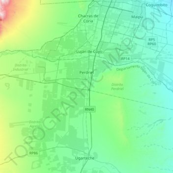
Name: Distrito Perdriel topographic map, elevation, terrain.
Average elevation: 3,222 ft
Minimum elevation: 2,874 ft
Maximum elevation: 3,684 ft
Make a donation
Gear up for your next adventure:
As an Amazon Associate, this site earns from qualifying purchases at no extra cost to you.
Other topographic maps
Click on a map to view its topography, its elevation and its terrain.
Puente del Inca
Argentina > Mendoza > Departamento Luján de Cuyo > Puente del Inca
Situated at 2,744 m (9,003 ft) above sea level, Puente del Inca has a warm-summer mediterranean continental climate (Dsb, according to the Köppen climate classification), as at least 4 months see an average temperature above 10 °C (50 °F) and at least one month sees an average temperature below 0 °C (32…
Average elevation: 9,862 ft