
Lynton topographic map
Click on the map to display elevation.
About this map
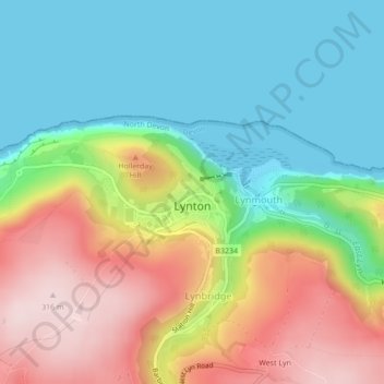
Name: Lynton topographic map, elevation, terrain.
Average elevation: 407 ft
Minimum elevation: 0 ft
Maximum elevation: 1,040 ft
Other topographic maps
Click on a map to view its topography, its elevation and its terrain.
St John's Chapel
United Kingdom > England > Devon > North Devon > Eastacombe
Average elevation: 256 ft
Woolacombe Sands
United Kingdom > England > Devon > North Devon > Woolacombe
Average elevation: 167 ft
Middle Haxton
United Kingdom > England > Devon > North Devon > Bratton Fleming
Average elevation: 689 ft
East Buckland
United Kingdom > England > Devon > North Devon > East Buckland
Average elevation: 604 ft