
Make a donation
Gear up for your next adventure:
As an Amazon Associate, this site earns from qualifying purchases at no extra cost to you.
Sinton topographic map
Click on the map to display elevation.
Make a donation
Gear up for your next adventure:
As an Amazon Associate, this site earns from qualifying purchases at no extra cost to you.
About this map
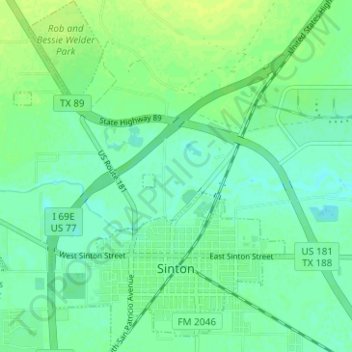
Name: Sinton topographic map, elevation, terrain.
Location: Sinton, San Patricio County, Texas, United States (28.02144 -97.53747 28.07669 -97.48919)
Average elevation: 59 ft
Minimum elevation: 39 ft
Maximum elevation: 82 ft
San Patricio County trails, hiking, mountain biking, running and outdoor activities
Make a donation
Gear up for your next adventure:
As an Amazon Associate, this site earns from qualifying purchases at no extra cost to you.
Other topographic maps
Click on a map to view its topography, its elevation and its terrain.
Garza-4th-6th Streets Colonia
United States > Texas > San Patricio County > Ingleside
Average elevation: 23 ft