
Thank you for supporting this site ❤️
Make a donation
Make a donation
Gear up for your next adventure:
As an Amazon Associate, this site earns from qualifying purchases at no extra cost to you.
Caerleon topographic map
Click on the map to display elevation.
Thank you for supporting this site ❤️
Make a donation
Make a donation
Gear up for your next adventure:
As an Amazon Associate, this site earns from qualifying purchases at no extra cost to you.
About this map
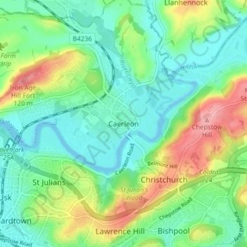
Name: Caerleon topographic map, elevation, terrain.
Location: Caerleon, Newport, Gwent, Wales, NP18 1AE, United Kingdom (51.58947 -2.97410 51.62947 -2.93410)
Average elevation: 121 ft
Minimum elevation: -7 ft
Maximum elevation: 381 ft
Thank you for supporting this site ❤️
Make a donation
Make a donation
Gear up for your next adventure:
As an Amazon Associate, this site earns from qualifying purchases at no extra cost to you.