
Make a donation
Gear up for your next adventure:
As an Amazon Associate, this site earns from qualifying purchases at no extra cost to you.
Alamagan Island topographic map
Click on the map to display elevation.
Make a donation
Gear up for your next adventure:
As an Amazon Associate, this site earns from qualifying purchases at no extra cost to you.
Alamagan Island
Alamagan is roughly elliptical in shape, with a length of 4.8 kilometers (3.0 mi), width of 4 km (2.5 mi), and area of 13 km2 (5.0 sq mi). The entire island is the summit of a stratovolcano which rises over 4,000 meters (13,120 ft) from the ocean floor, to an altitude of 744 m (2,441 ft) above sea level at Bandeera Peak, at the north-western edge. The volcano is topped by a caldera, 700–900 meters in diameter and about 370 m (1,210 ft) deep. There are three smaller cones to the north, northwest and south of the main crater. The volcano has not erupted in historical times, but by radiocarbon dating, eruptions occurred in 540 AD and 870 AD, with a potential dating error of around 100 years. These eruptions involved pyroclastic flows and had a VEI of 4. Claims of the most recent historical eruptions are not clear, eruptions might have occurred as late as 1887. Within the main crater and on the western slopes are a number of active fumaroles.
Make a donation
Gear up for your next adventure:
As an Amazon Associate, this site earns from qualifying purchases at no extra cost to you.
About this map
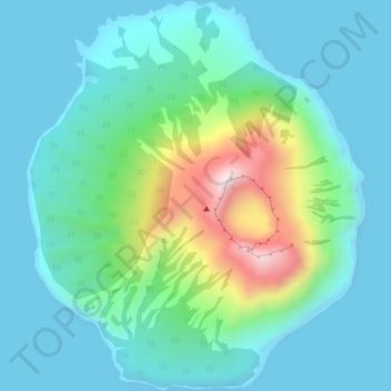
Name: Alamagan Island topographic map, elevation, terrain.
Average elevation: 486 ft
Minimum elevation: 0 ft
Maximum elevation: 2,329 ft
Northern Islands Municipality trails, hiking, mountain biking, running and outdoor activities
Make a donation
Gear up for your next adventure:
As an Amazon Associate, this site earns from qualifying purchases at no extra cost to you.
Other topographic maps
Click on a map to view its topography, its elevation and its terrain.
Pagan Island
United States > Northern Mariana Islands > Northern Islands Municipality > Shomushon
Average elevation: 115 ft
Mariana Islands
United States > Northern Mariana Islands > Northern Islands Municipality
Average elevation: 3 ft
Mariana Islands
United States > Northern Mariana Islands > Northern Islands Municipality
Average elevation: 3 ft
Asuncion Island
United States > Northern Mariana Islands > Northern Islands Municipality
Average elevation: 558 ft
Make a donation
Gear up for your next adventure:
As an Amazon Associate, this site earns from qualifying purchases at no extra cost to you.
Agrihan
United States > Northern Mariana Islands > Northern Islands Municipality
Average elevation: 584 ft