
Make a donation
Gear up for your next adventure:
As an Amazon Associate, this site earns from qualifying purchases at no extra cost to you.
Fukushima Prefecture topographic map
Click on the map to display elevation.
Make a donation
Gear up for your next adventure:
As an Amazon Associate, this site earns from qualifying purchases at no extra cost to you.
Fukushima Prefecture
Fukushima city is located in the Fukushima Basin's southwest area and nearby mountains. Located on the central eastern seaboard a part of the Pacifim rim. A region with high tectonic activity given its location where the Pacific and Eurasian continental plates collide - a part the Ring of Fire. " Aizuwakamatsu is located in the western part of Fukushima Prefecture, in the southeast part of Aizu basin. Mount Bandai is the highest mountain in the prefecture with an elevation of 1,819 m (5,968 ft). Mount Azuma-kofuji is an active stratovolcano that is 1,705 m (5,594 ft) tall with many onsen nearby. Lake Inawashiro is the 4th largest lake of Japan (103.3 km2 (39.9 sq mi)) in the center of the prefecture.
Make a donation
Gear up for your next adventure:
As an Amazon Associate, this site earns from qualifying purchases at no extra cost to you.
About this map
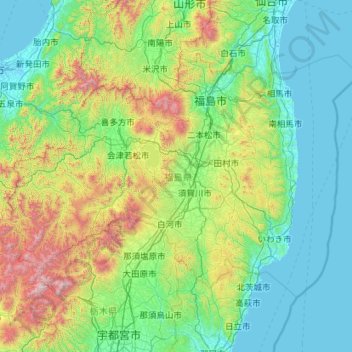
Name: Fukushima Prefecture topographic map, elevation, terrain.
Location: Fukushima Prefecture, Japan (36.74434 139.16474 37.98860 141.43766)
Average elevation: 1,319 ft
Minimum elevation: -10 ft
Maximum elevation: 8,379 ft
Make a donation
Gear up for your next adventure:
As an Amazon Associate, this site earns from qualifying purchases at no extra cost to you.
Other topographic maps
Click on a map to view its topography, its elevation and its terrain.
Make a donation
Gear up for your next adventure:
As an Amazon Associate, this site earns from qualifying purchases at no extra cost to you.
Mt. Kumotori
Mount Kumotori (雲取山, Kumotori-san) stands at the boundary of Tokyo, Saitama, and Yamanashi Prefectures on the island of Honshū, Japan. With an elevation of 2,017 metres (6,617 ft), its summit is the highest point in Tokyo. It separates the Okutama Mountains and the Okuchichibu Mountains. While it marks…
Average elevation: 5,331 ft
Make a donation
Gear up for your next adventure:
As an Amazon Associate, this site earns from qualifying purchases at no extra cost to you.