
Make a donation
Gear up for your next adventure:
As an Amazon Associate, this site earns from qualifying purchases at no extra cost to you.
Nieuwrode topographic map
Click on the map to display elevation.
Make a donation
Gear up for your next adventure:
As an Amazon Associate, this site earns from qualifying purchases at no extra cost to you.
Nieuwrode
Nieuwrode ligt in het Hageland en de hoogte varieert van 17-60 meter. De Grote Losting en de Kleine Losting stromen door het gebied. Verder zijn er getuigenheuvels zoals de Beninksberg ten westen van Nieuwrode, Benneberg en Kriesberg ten oosten van Nieuwrode. Ook ten oosten va Nieuwrode ligt het Mostingbos.
Make a donation
Gear up for your next adventure:
As an Amazon Associate, this site earns from qualifying purchases at no extra cost to you.
About this map
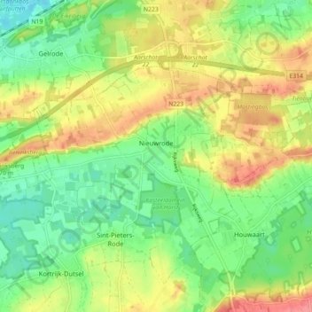
Name: Nieuwrode topographic map, elevation, terrain.
Location: Nieuwrode, Holsbeek, Leuven, Vlaams-Brabant, 3221, België (50.93086 4.78325 50.96320 4.87210)
Average elevation: 121 ft
Minimum elevation: 13 ft
Maximum elevation: 262 ft
Make a donation
Gear up for your next adventure:
As an Amazon Associate, this site earns from qualifying purchases at no extra cost to you.