Geolocate

Ginosa topographic map

Click on the map to display elevation.

About this map

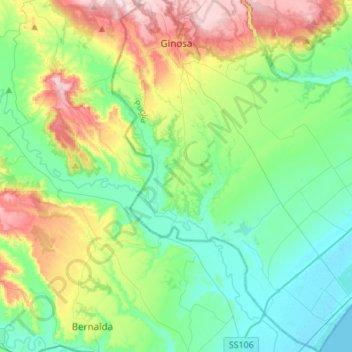
Name: Ginosa topographic map, elevation, terrain.

Location: Ginosa, Taranto, Apulia, Italy (40.39764 16.70618 40.60485 16.91065)

Average elevation: 351 ft

Minimum elevation: -3 ft

Maximum elevation: 1,194 ft

Other topographic maps

Click on a map to view its topography, its elevation and its terrain.

Marinara

Italy > Apulia > Taranto > Mottola

Average elevation: 856 ft

Saturo

Italy > Apulia > Taranto > Leporano

Average elevation: 39 ft

Gear up for your next adventure:

🔋Solar Power Banks - Keep your GPS and phone charged in remote wilderness areas
🥘Titanium Cookware - Durable, featherlight pots and pans for backpacking
🗺️Topographic Maps - Detailed topo maps for hiking, exploring and outdoor navigation
🛡️Bear Spray Outdoor - Protection in bear country hikes
🧢Sun Protection Hats - Wide-brimmed and UPF-rated hats for high-altitude sun safety

As an Amazon Associate, this site earns from qualifying purchases at no extra cost to you.