Geolocate

Losal topographic map

Click on the map to display elevation.

Losal

Losal is located at 27°24′N 74°55′E / 27.4°N 74.92°E / 27.4; 74.92. It has an average elevation of 410 meters (1345 feet). Losal lays 100 km northeast of Jaipur.

Wikipedia (CC-BY-SA 3.0)

About this map

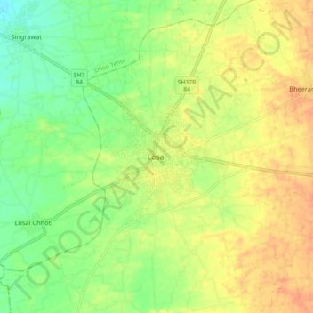
Name: Losal topographic map, elevation, terrain.

Location: Losal, Danta Ramgarh Tehsil, Sikar, Rajasthan, 332025, India (27.36043 74.87828 27.44043 74.95828)

Average elevation: 1,365 ft

Minimum elevation: 1,299 ft

Maximum elevation: 1,417 ft

Gear up for your next adventure:

🧭Pro Hiking Compasses - High-accuracy liquid-filled compasses for topographic orientation
📻Weather Alert Radios - Stay informed of storm risks while off-the-grid
📦Gear Storage Bags - Organize and protect outdoor equipment
🔦Powerful Headlamps - Ultra-bright hands-free lighting for night navigation
🪶Fire Starter Kit - Reliable fire starter for survival and camping

As an Amazon Associate, this site earns from qualifying purchases at no extra cost to you.