
Thank you for supporting this site ❤️
Make a donation
Make a donation
Gear up for your next adventure:
As an Amazon Associate, this site earns from qualifying purchases at no extra cost to you.
Stangengrün topographic map
Click on the map to display elevation.
Thank you for supporting this site ❤️
Make a donation
Make a donation
Gear up for your next adventure:
As an Amazon Associate, this site earns from qualifying purchases at no extra cost to you.
About this map
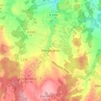
Name: Stangengrün topographic map, elevation, terrain.
Location: Stangengrün, Kirchberg, Zwickau, Sachsen, 08107, Deutschland (50.56600 12.43279 50.60600 12.47279)
Average elevation: 1,529 ft
Minimum elevation: 1,270 ft
Maximum elevation: 1,768 ft
Thank you for supporting this site ❤️
Make a donation
Make a donation
Gear up for your next adventure:
As an Amazon Associate, this site earns from qualifying purchases at no extra cost to you.