
Ivvavik National Park topographic map
Interactive map
Click on the map to display elevation.
About this map
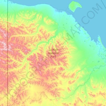
Name: Ivvavik National Park topographic map, elevation, terrain.
Location: Ivvavik National Park, Yukon, Canada (68.56067 -141.00086 69.64783 -138.13382)
Average elevation: 1,401 ft
Minimum elevation: -13 ft
Maximum elevation: 6,381 ft
Other topographic maps
Click on a map to view its topography, its elevation and its terrain.
Kluane National Park and Reserve
Kluane National Park and Reserve, Yukon, Canada
Average elevation: 5,039 ft
Two Mile Village
Canada > Yukon > Watson Lake
Two Mile Village, Watson Lake, Yukon, Y0A 1C0, Canada
Average elevation: 2,306 ft
Destruction Bay
Canada > Yukon > Destruction Bay
Destruction Bay, Yukon, Y0B 1H0, Canada
Average elevation: 2,930 ft
Dawson City
Canada > Yukon > Dawson City > Dawson City
Dawson City, Yukon, Y0B 1G0, Canada
Average elevation: 1,673 ft
Yukon, Unorganized
City of Whitehorse, Yukon, Unorganized, Yukon, Canada
Average elevation: 3,314 ft
Swift River
Canada > Yukon > Swift River
Swift River, Yukon, Unorganized, Yukon, Canada
Average elevation: 3,563 ft