Geolocate

Kelberg topographic map

Click on the map to display elevation.

About this map
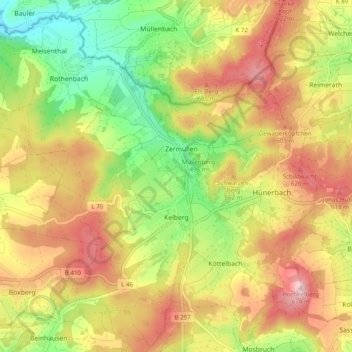
Name: Kelberg topographic map, elevation, terrain.

Location: Kelberg, Landkreis Vulkaneifel, Rhineland-Palatinate, 53539, Germany (50.26345 6.85917 50.32421 6.95749)

Average elevation: 1,729 ft

Minimum elevation: 1,289 ft

Maximum elevation: 2,165 ft

Other topographic maps

Click on a map to view its topography, its elevation and its terrain.
Gear up for your next adventure:

🎒Day Hiking Backpack - Lightweight backpack perfect for day trips and outdoor adventures
🥾Hiking Shoes - Durable and comfortable shoes for trail hiking
👟Men's Trail Runners - Lightweight footwear for fast-paced exploration and light hiking
🥤Water Filter Bottle - All‑in‑one filter bottle for safe hydration
🧢Sun Protection Hats - Wide-brimmed and UPF-rated hats for high-altitude sun safety

As an Amazon Associate, this site earns from qualifying purchases at no extra cost to you.