Geolocate

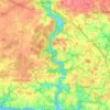
Kersalut topographic map

Click on the map to display elevation.

About this map

Name: Kersalut topographic map, elevation, terrain.

Location: Kersalut, Clohars-Carnoët, Quimper, Finistère, Bretagne, France métropolitaine, 29360, France (47.78213 -3.62351 47.82213 -3.58351)

Average elevation: 167 ft

Minimum elevation: 59 ft

Maximum elevation: 223 ft

Other topographic maps

Click on a map to view its topography, its elevation and its terrain.
La Laïta

France > Bretagne > Finistère > Clohars-Carnoët

Average elevation: 148 ft

Gear up for your next adventure:

🥘Titanium Cookware - Durable, featherlight pots and pans for backpacking
🧭Outdoor Navigation Book - Learn advanced navigation skills
🛏️Cold Weather Sleeping Bag - Warm sleeping bag for cold conditions
🗺️Topographic Maps - Detailed topo maps for hiking, exploring and outdoor navigation
🔪Outdoor Multitools - Essential survival tools for gear repair and field use

As an Amazon Associate, this site earns from qualifying purchases at no extra cost to you.