
Make a donation
Gear up for your next adventure:
As an Amazon Associate, this site earns from qualifying purchases at no extra cost to you.
Kissimmee topographic map
Click on the map to display elevation.
Make a donation
Gear up for your next adventure:
As an Amazon Associate, this site earns from qualifying purchases at no extra cost to you.
About this map
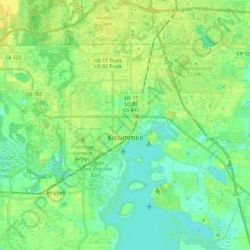
Name: Kissimmee topographic map, elevation, terrain.
Location: Kissimmee, Osceola County, Florida, United States (28.25075 -81.48539 28.34796 -81.31477)
Average elevation: 75 ft
Minimum elevation: 43 ft
Maximum elevation: 125 ft
Osceola County trails, hiking, mountain biking, running and outdoor activities
Make a donation
Gear up for your next adventure:
As an Amazon Associate, this site earns from qualifying purchases at no extra cost to you.
Other topographic maps
Click on a map to view its topography, its elevation and its terrain.
Make a donation
Gear up for your next adventure:
As an Amazon Associate, this site earns from qualifying purchases at no extra cost to you.
Make a donation
Gear up for your next adventure:
As an Amazon Associate, this site earns from qualifying purchases at no extra cost to you.
Twin Oaks Conservation Area
United States > Florida > Osceola County > Kissimmee
Average elevation: 59 ft