Geolocate

Chevening topographic map

Click on the map to display elevation.

About this map

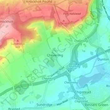
Name: Chevening topographic map, elevation, terrain.

Location: Chevening, Sevenoaks, Kent, England, TN14 6HG, United Kingdom (51.27725 0.11464 51.31725 0.15464)

Average elevation: 413 ft

Minimum elevation: 230 ft

Maximum elevation: 797 ft

Other topographic maps

Click on a map to view its topography, its elevation and its terrain.

Eynsford

United Kingdom > England > Kent > Sevenoaks

Average elevation: 341 ft

Edenbridge

United Kingdom > England > Kent > Sevenoaks

Average elevation: 223 ft

Gear up for your next adventure:

🔥Fast-Boil Camping Stoves - Efficient cooking systems for quick trail meals
🧴Hand Sanitizer - Keep hands clean while hiking
🛰️Handheld GPS Units - Professional satellite navigators for precise backcountry mapping
🧤Hiking Gloves - Protective gloves for rugged trails
🪶Paracord Bracelet - Survival bracelet with built‑in tools

As an Amazon Associate, this site earns from qualifying purchases at no extra cost to you.