Geolocate

Eynsford topographic map

Click on the map to display elevation.

About this map

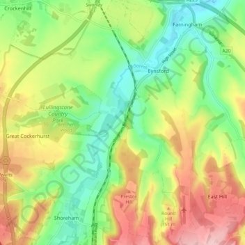
Name: Eynsford topographic map, elevation, terrain.

Location: Eynsford, Sevenoaks, Kent, England, United Kingdom (51.32744 0.15760 51.38397 0.23640)

Average elevation: 341 ft

Minimum elevation: 98 ft

Maximum elevation: 669 ft

Other topographic maps

Click on a map to view its topography, its elevation and its terrain.

Chevening

United Kingdom > England > Kent > Sevenoaks

Average elevation: 413 ft

Weardale

United Kingdom > England > Kent > Sevenoaks > French Street

Average elevation: 561 ft

Gear up for your next adventure:

👓Polarized Sunglasses - Outdoor sunglasses for glare reduction
🪶LED Camping Lantern - Bright lantern for camp lighting
🌡️Handheld Weather Meters - Measure wind, temp, and pressure for safe mountain travel
🔥Fast-Boil Camping Stoves - Efficient cooking systems for quick trail meals
👖Convertible Hiking Pants - Versatile zip-off pants for changing altitudes and temperatures

As an Amazon Associate, this site earns from qualifying purchases at no extra cost to you.