
Make a donation
Gear up for your next adventure:
As an Amazon Associate, this site earns from qualifying purchases at no extra cost to you.
Vinces topographic map
Click on the map to display elevation.
Make a donation
Gear up for your next adventure:
As an Amazon Associate, this site earns from qualifying purchases at no extra cost to you.
Vinces
Vinces, también conocida como San Lorenzo de Vinces, es una ciudad ecuatoriana; cabecera cantonal del Cantón Vinces, así como la quinta urbe más grande y poblada de la Provincia de Los Ríos. Se localiza al centro de la región litoral del Ecuador, en una extensa llanura, atravesada por el río Vinces, a una altitud de 17 msnm y con un clima lluvioso tropical de 27 °C en promedio.
Make a donation
Gear up for your next adventure:
As an Amazon Associate, this site earns from qualifying purchases at no extra cost to you.
About this map
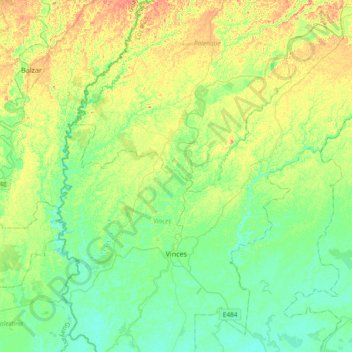
Name: Vinces topographic map, elevation, terrain.
Location: Vinces, Los Ríos, 120502, Ecuador (-1.64390 -79.87823 -1.30852 -79.50643)
Average elevation: 72 ft
Minimum elevation: 16 ft
Maximum elevation: 171 ft
Make a donation
Gear up for your next adventure:
As an Amazon Associate, this site earns from qualifying purchases at no extra cost to you.
Other topographic maps
Click on a map to view its topography, its elevation and its terrain.