Geolocate

Binan topographic map

Click on the map to display elevation.

About this map

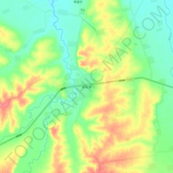
Name: Binan topographic map, elevation, terrain.

Location: Binan, Harbin, Heilongjiang, China (45.80171 127.72115 45.88171 127.80115)

Average elevation: 466 ft

Minimum elevation: 374 ft

Maximum elevation: 600 ft

Other topographic maps

Click on a map to view its topography, its elevation and its terrain.

Nangang District

China > Heilongjiang > Harbin

Average elevation: 522 ft

Nangang District

China > Heilongjiang > Harbin

Average elevation: 522 ft

Shangzhi

China > Heilongjiang > Harbin

Average elevation: 1,352 ft

Nangang District

China > Heilongjiang > Harbin

Average elevation: 522 ft

Yilan County

China > Heilongjiang > Harbin

Average elevation: 630 ft

Gear up for your next adventure:

🧦Merino Wool Socks - Moisture-wicking, blister-preventing socks for long treks
🔥Fast-Boil Camping Stoves - Efficient cooking systems for quick trail meals
🪶Wildlife Field Guides - Learn animal tracking and species ID
🎒Waterproof Dry Bags - Keep your electronics and maps dry inside your pack
📖Nature Tracking Books - Learn to track wildlife and terrain

As an Amazon Associate, this site earns from qualifying purchases at no extra cost to you.