
Make a donation
Gear up for your next adventure:
As an Amazon Associate, this site earns from qualifying purchases at no extra cost to you.
Mykonos topographic map
Click on the map to display elevation.
Make a donation
Gear up for your next adventure:
As an Amazon Associate, this site earns from qualifying purchases at no extra cost to you.
Mykonos
Mykonos (/ˈmɪkənɒs, -noʊs/, UK also /ˈmiːk-/; Greek: Μύκονος [ˈmikonos]) is a Greek island, part of the Cyclades, lying between Tinos, Syros, Paros and Naxos. The island has an area of 85.5 square kilometres (33.0 sq mi) and rises to an elevation of 341 metres (1,119 feet) at its highest point. At the 2021 census, there were 10,704 inhabitants, most of whom lived in the largest town, Mykonos, which is on the west coast. The town is also known as Chora (i.e. 'Town' in Greek, following the common practice in Greece when the name of the island itself is the same as the name of the principal town).
Make a donation
Gear up for your next adventure:
As an Amazon Associate, this site earns from qualifying purchases at no extra cost to you.
About this map
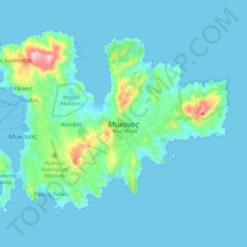
Name: Mykonos topographic map, elevation, terrain.
Average elevation: 125 ft
Minimum elevation: -3 ft
Maximum elevation: 1,220 ft
Make a donation
Gear up for your next adventure:
As an Amazon Associate, this site earns from qualifying purchases at no extra cost to you.