
Make a donation
Gear up for your next adventure:
As an Amazon Associate, this site earns from qualifying purchases at no extra cost to you.
Wolaita Sodo topographic map
Click on the map to display elevation.
Make a donation
Gear up for your next adventure:
As an Amazon Associate, this site earns from qualifying purchases at no extra cost to you.
Wolaita Sodo
Sodo (Amharic: ሶዶ) or officially Wolaita Sodo (Amharic: ወላይታ ሶዶ, Wolaytta: Wolaytta Sooddo) is a city in south Ethiopia. The City is a political and administrative center of the Wolaita Zone and South Ethiopia Regional State. It has a latitude and longitude of 6°54′N 37°45′E / 6.900°N 37.750°E / 6.900; 37.750 with an elevation between 1,600 and 2,100 metres (5,200 and 6,900 feet) above sea level. It was part of the former Sodo woreda which included Sodo Zuria which completely surrounds it.
Make a donation
Gear up for your next adventure:
As an Amazon Associate, this site earns from qualifying purchases at no extra cost to you.
About this map
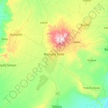
Name: Wolaita Sodo topographic map, elevation, terrain.
Average elevation: 6,145 ft
Minimum elevation: 4,459 ft
Maximum elevation: 9,695 ft
Make a donation
Gear up for your next adventure:
As an Amazon Associate, this site earns from qualifying purchases at no extra cost to you.
Other topographic maps
Click on a map to view its topography, its elevation and its terrain.
Boditi
Ethiopia > South Ethiopia Regional State
Boditi, (Amharic: ቦዲቲ) or (Wolayttattuwa: Bodditte) is a city and separate district in south central Ethiopia. The city is located in the Wolaita Zone of the South Ethiopia Regional State. This city has a latitude and longitude of 6°58′N 37°52′E / 6.967°N 37.867°E / 6.967; 37.867 with an…
Average elevation: 6,503 ft
Bombe
Ethiopia > South Ethiopia Regional State
Bombe (Geʽez: ቦምቤ) is a town and separate district in Wolayita Zone of the South Ethiopia Regional State, Ethiopia. Bombe town is located 325 km (202 mi) and 55 km (34 mi) away from Addis Ababa and Wolaita Sodo town through Hossana exit, respectively. Bombe town is used as an administrative capital of…
Average elevation: 4,977 ft
Nech Sar National Park
Ethiopia > South Ethiopia Regional State > Arba Minch
Average elevation: 3,986 ft