
Thank you for supporting this site ❤️
Make a donation
Make a donation
Gear up for your next adventure:
As an Amazon Associate, this site earns from qualifying purchases at no extra cost to you.
Sayaboury topographic map
Click on the map to display elevation.
Thank you for supporting this site ❤️
Make a donation
Make a donation
Gear up for your next adventure:
As an Amazon Associate, this site earns from qualifying purchases at no extra cost to you.
About this map
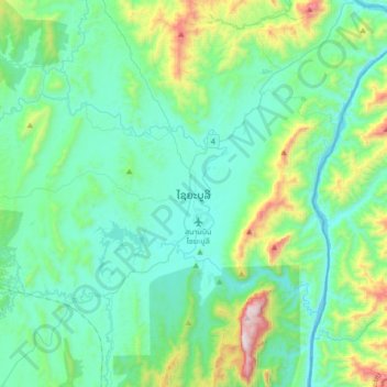
Name: Sayaboury topographic map, elevation, terrain.
Location: Sayaboury, Xayabury District, Sainyabuli Province, Laos (19.10531 101.54592 19.42531 101.86592)
Average elevation: 1,604 ft
Minimum elevation: 771 ft
Maximum elevation: 5,226 ft
Thank you for supporting this site ❤️
Make a donation
Make a donation
Gear up for your next adventure:
As an Amazon Associate, this site earns from qualifying purchases at no extra cost to you.