Geolocate

Masinloc topographic map

Click on the map to display elevation.

About this map

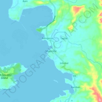
Name: Masinloc topographic map, elevation, terrain.

Location: Masinloc, Zambales, Central Luzon, 2211, Philippines (15.49864 119.90969 15.57864 119.98969)

Average elevation: 43 ft

Minimum elevation: 0 ft

Maximum elevation: 351 ft

Other topographic maps

Click on a map to view its topography, its elevation and its terrain.

Hermana Mayor Island

Philippines > Zambales

Average elevation: 13 ft

Capones

Philippines > Zambales

Average elevation: 3 ft

Hermana Menor Island

Philippines > Zambales

Average elevation: 3 ft

Subic

Philippines > Zambales

Average elevation: 558 ft

Anawangin Cove

Philippines > Zambales

Average elevation: 197 ft

Nagsasa Cove

Philippines > Zambales

Average elevation: 125 ft

Camara

Philippines > Zambales

Average elevation: 0 ft

Redondo Peninsula

Philippines > Zambales

Average elevation: 394 ft

Mangan-vaca River

Philippines > Zambales > Subic > Ilwas

Average elevation: 108 ft

Santo Tomas River

Philippines > Zambales > Rabanes

Average elevation: 427 ft

Acid Lake

Philippines > Zambales > Subic

Average elevation: 1,280 ft

Mapanuepe Lake

Philippines > Zambales > Aglao

Average elevation: 640 ft

Subic

Philippines > Zambales

Average elevation: 558 ft

Subic

Philippines > Zambales

Average elevation: 558 ft

Nagsasa Cove

Philippines > Zambales

Average elevation: 125 ft

Santo Tomas River

Philippines > Zambales > Rabanes

Average elevation: 427 ft

Gear up for your next adventure:

🦟Ultrasonic Repellers - Create a bug-free zone at your camp or rest stop
📖Nature Tracking Books - Learn to track wildlife and terrain
🪶Compact Camp Shovel - Folding shovel for campsite tasks
🔦Compact Flashlight - Reliable flashlight for emergencies
🕶️Glacier Sunglasses - Side shields to protect eyes from high-altitude snow glare

As an Amazon Associate, this site earns from qualifying purchases at no extra cost to you.