
Zgorzelec County topographic map
Click on the map to display elevation.
About this map
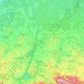
Name: Zgorzelec County topographic map, elevation, terrain.
Location: Zgorzelec County, Lower Silesian Voivodeship, Poland (50.86193 14.81737 51.46403 15.33992)
Average elevation: 850 ft
Minimum elevation: 157 ft
Maximum elevation: 3,684 ft
Other topographic maps
Click on a map to view its topography, its elevation and its terrain.
Sudety
Poland > Lower Silesian Voivodeship > Ząbkowice Śląskie County > Starczówek
Average elevation: 961 ft
Polanica
Poland > Lower Silesian Voivodeship > Ząbkowice Śląskie County > Nowina
Average elevation: 810 ft
Śnieżka / Sněžka
Poland > Lower Silesian Voivodeship > Karkonosze County > Karpacz
Due to high altitude the climate is maritime polar (Köppen: ET) not far from a continental subpolar climate (Dfc). The difference should be at least 6 °C lower on annual average compared to the weather station in the plains.
Average elevation: 4,144 ft
Szary Kamień
Poland > Lower Silesian Voivodeship > Kłodzko County > Lądek-Zdrój
Average elevation: 1,614 ft
Pop
Poland > Lower Silesian Voivodeship > Zgorzelec County > Studniska Dolne
Average elevation: 712 ft